N/A
N/A
Partners: The Watershed Foundation, Indiana Department of Environmental Management's Lake and River Enhancement (LARE) ProgramAbout this project
Crooked Lake is the very first lake in our watershed – so it is very important that it remains in good health for all of us! The 208 acre, 110 ft. deep lake, surrounded by forests, native plants and many homes, has been declared one of the cleanest natural lake in all of Indiana.
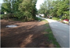
Crooked Lake Association residents recently collaborated to dredge the smaller lake of the two, which had filled with sediment due to a stream that empties directly into it. The stream forms the eastern boundary (at least in part) of the Crooked Lake Nature Preserve. Thus, once the dredging was completed a few years ago, it was time to address the “source” of the sediment in the channel.
TWF worked with the Association to determine that the source of the sediment comes after heavy rains that severely erode the banks of the meandering stream and produces a chocolatey, sediment-laden flow into the channel, and thus into the lake.
A comprehensive study funded by a grant requested by The Watershed Foundation, is currently underway. TWF’s conservationists are overseeing the project, funded by the grant from the Indiana Department of Environmental Management’s Lake and River Enhancement (LARE) fund.
As you can see, many partners have to work together to get important projects completed for our lakes. Together, we are making a difference!
Project Type
- Lakeshore Stabilization